


Marine Radar Map
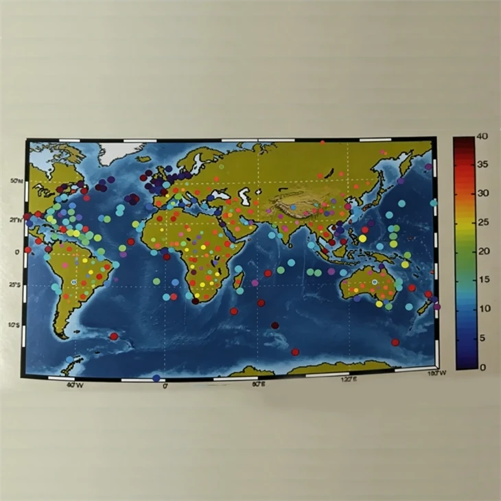
This professional marine radar mapping system serves ocean environment monitoring and over-the-horizon radar detection. It converts messy marine data like sea surface weather conditions, evaporation duct distribution and radar propagation performance into intuitive interactive maps, helping you analyze marine meteorology, assess radar detection capacity and support sea target detection missions easily.
Description
This professional marine radar mapping system serves ocean environment monitoring and over-the-horizon radar detection. It converts messy marine data like sea surface weather conditions, evaporation duct distribution and radar propagation performance into intuitive interactive maps, helping you analyze marine meteorology, assess radar detection capacity and support sea target detection missions easily.
Features
It displays ocean weather and radar signal data via vivid heat maps and overlay graphics for quick feature spotting. It gathers wind, temperature and evaporation duct data from diverse devices and connects smoothly with over-the-horizon radar systems. Professional calculation models help judge radar detection performance under changing marine atmospheres. Users can pick sea zones, adjust time frames and sort data flexibly for fast information query. It works independently or within networks, fitting maritime service, radar evaluation and ocean research work perfectly.
Core Functional Modules
Heat maps show sea temperature, wind and other weather stats across chosen ocean ranges to spot key weather zones. Custom models turn evaporation duct data into visuals, letting users grasp radar transmission surroundings clearly. It produces detection range and signal loss graphs to assess real-time and predicted radar working status. Historical data can be filtered, played back and compared to analyze trends and review past marine conditions.
Technical indicators
|
Measuring range of sea surface temperature |
-10℃ ~ 60℃ |
|
Measuring range of sea surface air temperature |
-10℃ ~ 60℃ |
|
Measuring range of relative humidity |
20%RH ~ 100%RH |
|
Measuring range of pressure |
800hPa ~ 1060hPa |
|
Measuring range of wind speed |
0.5m/s ~ 40m/s |
Application Fields
Marine Meteorological Operations and Analysis: Provides operational meteorologists and oceanographers with a unified geospatial visualization environment for real-time and historical sea-surface meteorological analysis, supporting marine weather forecasting, ocean environment assessment, and hydrometeorological monitoring across global and regional sea areas.
Over-the-Horizon Radar Detection Support: Delivers the evaporation duct distribution and atmospheric propagation environment data required to assess, predict, and optimize OTH radar detection capability - providing radar operators and mission planners with situational awareness of how current marine atmospheric conditions affect detection range and performance.
Sea-Surface Target Detection Performance Assessment: Combines atmospheric duct diagnostics with radar propagation modeling to quantitatively evaluate target detection probability and coverage under real-world marine environmental conditions, supporting mission planning and detection system performance verification.
Ocean Environment Scientific Research: Provides marine atmospheric scientists and oceanographers with a flexible analytical platform for evaporation duct behavior research, atmospheric boundary layer studies, radar wave propagation modeling, and ocean-atmosphere interaction investigations.
Maritime Navigation and Voyage Meteorological Support: Supplies real-time and forecast marine meteorological visualization data - wind field, sea-surface temperature, pressure distribution - to support vessel route planning, voyage weather assessment, and maritime operational safety.
Ocean Engineering Environmental Analysis: Delivers spatially referenced marine meteorological and atmospheric propagation data for offshore structure siting, subsea infrastructure planning, and ocean engineering project environmental impact assessment.
Customized Solutions and Technical Support
We offer comprehensive technical support tailored to your business scenarios and needs, whether you require a complete customized solution or partial system adjustments.
We provide the following customized services:
- Multilingual Software Interface: Supports global multilingual switching to meet the needs of cross-border business and localized operations.
- Data Communication Integration: Open data interfaces for easy integration into your existing system platform.
- Regional Meteorological Standard Alignment: Targeted calibration and algorithm adaptation based on meteorological standards of your country or industry.
- Ground Station Configuration: Flexible combinations of ground station hardware and software to optimize data acquisition in special environments.
More Meteorological Equipment and Business Partnerships
If you are looking for more professional meteorological equipment or require detailed project solutions, please contact our team of technical experts directly. We will provide you with professional assistance in the following areas:
- Obtain detailed product specifications and technical white papers
- System configuration and selection recommendations for complex scenarios
- Deep OEM/ODM customization and contract manufacturing cooperation
- Project budget quotations, bidding support, and overall solutions
Our engineers will provide you with professional responses as soon as possible.
Hot Tags: marine radar map, China marine radar map manufacturers, suppliers, factory, Marine Radar Map, OTH Radar System, Over The Horizon Radar System, radar oth
Send Inquiry
You Might Also Like


